Event Overview and Goals
The SmartConnect development team held an on-site networking event on November 10th at the American Shooting Centers location in Houston, TX. Representatives from Shell Renewables, Frost Brown Todd, LitCon Group, Procore Software, and SmartConnect Connected Workforce Solutions were in attendance.
The activity encapsulated the challenges a Real Time Location Solution must overcome to be relevant in today’s event-based construction market:
- Ease of deployment – the system should use minimal or no on-site infrastructure and be set up in a day or less
- Full workforce support – the solution can be deployed cost effectively to all workers within a single site.
- Easy to use – Both workers and managers gain benefit from the system
- Reliable information in all environments – uninterrupted and near real time data from assets.
- Adaptable business rules for safety and efficiency – the application should support the safety and efficiency goals of the site.
This article describes the steps taken to prepare the SmartConnect Connected Worker solution for the event. Example near real time safety and efficiency information is discussed related to its relevance to the event goals. We conclude with safety and efficiency reports automatically generated from the day’s activities.
default closed
Deploying SmartConnect
System Set Up and Asset Profile Configuration
A location was selected 48 hours before the event took place. Setup prior to walking on site included:
- Hardware selection and preparation
- Creating asset profiles
- Project zone mapping
- Project events configuration
- Ensuring data privacy
Except for the first item, all tasks were handled in the SmartConnect Application admin mode. SmartBadges primarily used GPS for position data during the field day. BLE or LoRaHF beacons can also be set on site in case of high structure coverage.
Necessary Hardware
The location was primarily open field with no power or ability to set up a gateway at altitude. Hardware provided for the field day included:
|
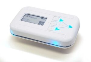
Ten (10) SMC-T4 SmartBadges |
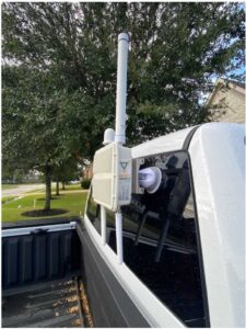
One (1) SmartConnect LoRa Gateway mounted in a mobile configuration to the SmartConnect vehicle and powered by an external battery pack. |
Mapping and Geo-fencing
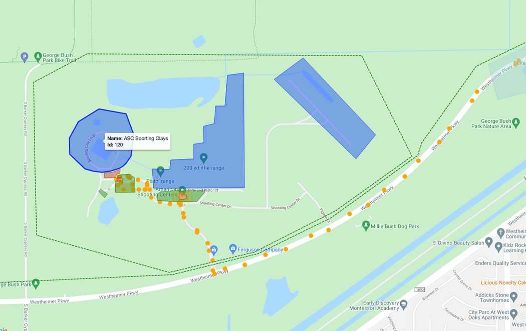
Project mapping within the application describes any areas that have business rules (such as restricted areas) and aids in the generation of workplace metrics. SmartConnect uses Google maps as the base layer however visualization options include custom drone images, custom satellite images, or uploaded map tiles.
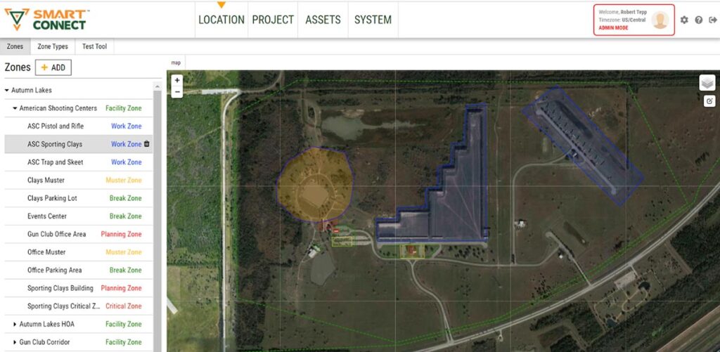
American Shooting Centers Facility Satellite View with Sporting Clays Area Highlighted Orange.
14 Geofenced zones were created for the demonstration:
- 3 – Facility Zones were created for monitoring of travel and location throughout the day.
- 3 – Work Zones to enable metric reporting on percent of time spent in active work.
- 2 – Planning Zones to enable metric reporting on percent of time in planning/preparation for active work.
- 3 – Break Zones to enable metric reporting on percent of time in break areas.
- 2 – Muster Zones to enable monitoring of asset progress towards muster zone and completion of emergency mustering.
- 1 – Critical Zone to enable monitoring and reporting of critical zone entries and duration of time spent in critical zone.
Event Configuration
In the SmartConnect dictionary, an event is any action or activity that creates a system reaction. A reaction can be triggered by the SmartBadge man down button, entering an area which the application considers “restricted”, or even an automated muster.
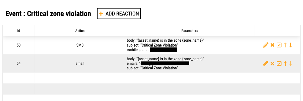
The SmartConnect application allows for quick connections between assets, zones, and optional expected reactions such as triggering a text notification, email, or an application alert.
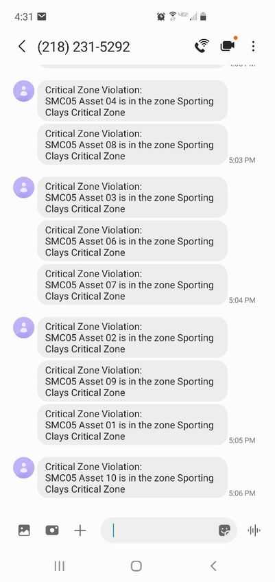
For the demonstration, a restricted area zone was connected to an SMS (text) event. Participants received text messages when SmartBadges entered a “critical” zone.
Data Grouping / Data Privacy
Data groupings help partition how information is represented and recorded. Data privacy is accomplished in two (2) separate methods. First, location data is not recorded by the system unless the location is within a facility zone boundary. In this way, worker privacy is maintained when carrying badges off-site and aids in system execution by not requiring the badges to stay onsite to be handed out each day.
Data privacy control is also achieved by giving “department” categories only access to specific groupings of data. Software users can only access information related to assets that are in the categories assigned to their department or assets that are considered public.
Field Day Metrics and Results
Field Day Results – Understanding Who, Where, and When
Asset Location Trace – view of route from SmartConnect to ASC to Houston Country Club to ASC to Pablo’s to SmartConnect.
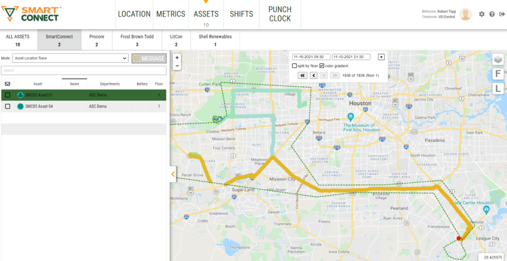
A screenshot of location tracing for “Asset 1” is shown above. The system demonstrated mobility and accuracy despite tracking movement within the large area defined by the green dashed facility zone area. During the event all badges backhauled data through the vehicle-mounted LoRa gateway running SmartConnect’s LoRaDAN firmware. The SmartBadges reported data once every 19 seconds.
One can see that there is a brief gap in data at two points at the left of the map area where the group left boundaries of the facility zone. Not collecting data outside of a defined area enforces employee privacy control.
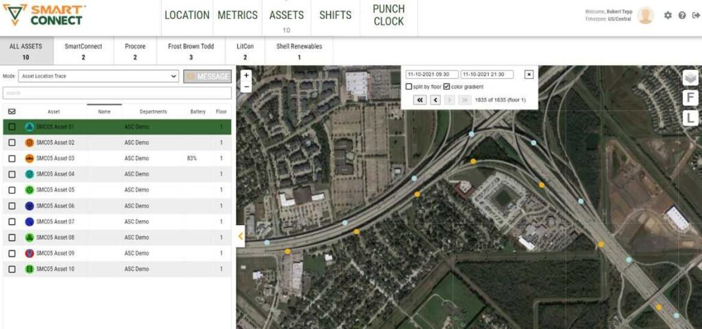
Asset Trace of Asset 1 at Hwy 45 x Hwy 8 interchange (blue outbound, orange inbound) showing accuracy of tracking with badge inside a vehicle traveling at highway speeds – note accuracy to correct lane of highway and on exchange ramps.
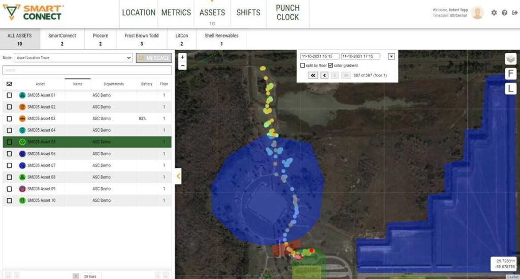
Asset Location Trace of Asset 5 from 3:15 pm to 5:15 pm- 387 data points (1 per every 19 seconds) – view of route from Sporting Clays Parking Lot, through Critical Zone at course entry to Sporting Clays stations and returning to parking lot. Data points at parking lot showing blue, green, and orange demonstrating start at lot, intermediate trip back to lot to drop off person, and final return to lot at end of day.
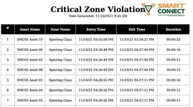
A critical zone was established near the entry to the Sporting Clays course (between parking lot and course area) to track when assets entered and/or exited the course. For the field day scenario, a critical zone entry triggered a text message as well as a report entry. An excerpt of the report shows how a safety manager can gain useful insight into worker at risk behavior.
Efficiency Monitoring
The SmartConnect application mines the thousands (or millions) of data points to present real time actionable information at the job site. The Zone Time Breakdown graph to the right presents the percent time spent associated with each of the four categories in a stacked bar chart.
During the field day event, a live Metrics screen displayed real-time Zone Efficiency tracking information. The completed demonstration results showed participants spent:
- 50% of time in Work Zones (shooting clays)
- 2% in Planning Zones
- 9% in Break Zones
- 39% in Travel between Zones on the day of the event (November 10th).
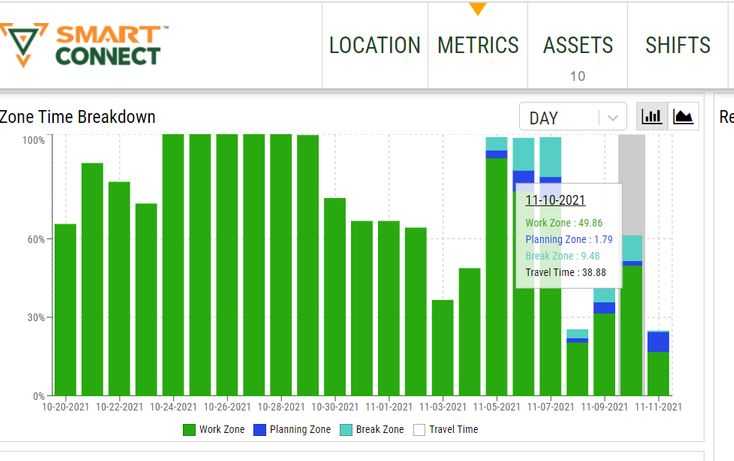
Note: Due to unfamiliarity with the course, the far north section was not included in the work zone and was recorded as travel time.
Proximity Alerting and Contact Tracing
The SmartConnect proximity alerting feature was enabled for the demonstration. When enabled, SmartBadges will determine when they are within approximately 6 feet of each other and report the time and duration by badge encountered. This data is then logged and used to generate specific contact tracing reports for a selected individual, or the entire data set can be exported for all people.
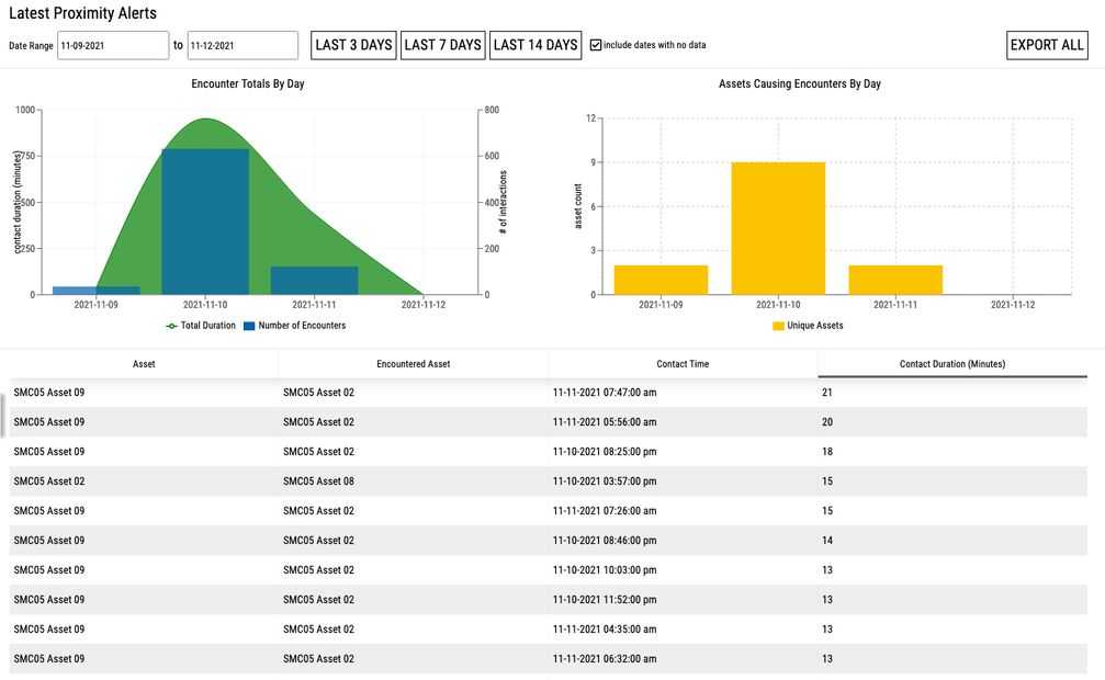
The Contact Tracing Report by individual allows for a specific time range to be polled (based on a desired range ahead of reporting a positive COVID test – typically 3 days) and return a listing of the other people encountered presented in a risk ranking based on total duration of exposure over the selected period.
Additional Safety Feature Sets
 Several key safety feature sets were demonstrated during the event:
- Man-Down / Call for Help: The SmartBadge has a large center button that may be pressed for 3-seconds to activate a man down / call for help alarm. This alarm will then be logged into in the system where an alert will be generated requiring an individual to resolve the man-down alarm.
- Fall Alerts: The SMC-T4 badge contains an accelerometer that allows for a proprietary algorithm to detect when a badge has fallen 6 feet and sustained an impact. The badge will then automatically report such a fall which will be logged into the system and an alert generated requiring an individual to resolve the Fall Alert.
- Emergency Mustering: Once initiated, the SmartConnect will send an alert and message to each of the people to be mustered who are currently within the facility and notify them to report to the nearest muster zone. The system will track each of the asset’s progress towards mustering zones and automatically check the asset into the muster zone once they reach the geofenced boundaries of the zone. Once all assets have reached the muster zones, the muster will automatically come to completion and the badges will receive a message telling them stay in the muster zone until an All Clear is received. Once management is satisfied that the muster is complete, they can select the All-Clear button that will appear upon muster completion and all badges will receive the “All-Clear” message. Reports are available for selected date ranges detailing duration of the muster events along with a list of other relevant information.

